| Prev | Next |
ArcGIS Toolbox Pages
The ArcGIS Toolbox pages provide elements and connectors that you can use to model ArcGIS geodatabase concepts and relationships. The ArcGIS Toolbox consists of five Core pages:
- Domains - for coded value and range domains
- Features and Tables - for custom feature types and tables
- Network Features - to identify geometric network and topology Packages
- Raster - for raster datasets
- Workspace - for ArcGIS workspace and spatial reference information
Two additional Toolboxes group the objects used specifically in creating Geometric Network and Topology diagrams.
Access
On the Diagram Toolbox, click on  to display the 'Find Toolbox Item' dialog and specify 'ArcGIS:
- Core'
- Geometric Network' or
- Topology'
|
Ribbon |
Design > Diagram > Toolbox |
|
Keyboard Shortcuts |
|
ArcGIS Toolbox Pages
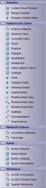
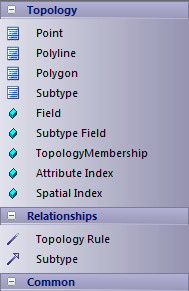
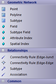
Diagram toolbox icons
Toolbox Icon |
Description |
|---|---|
|
Packages |
|
|
ArcGIS Workspace |
The geodatabase workspace Package, which holds all the ArcGIS modeling elements. Export the contents of this Package to produce the Geodatabase XML Workspace Document, which can be imported to Esri ArcCatalog. |
|
ArcGIS Schema View |
A stereotyped Package that represents a subset of the geodatabase schema defined within the ArcGIS Workspace Package. ArcGIS Schema View Packages are useful if you need to create partial or modular schemas based on your complete geodatabase design. You can create any number of ArcGIS Schema View Packages under your ArcGIS Workspace Package. Add this element to a diagram under your workspace, then create a UML Dependency connector from it to each Package to include in the generated XML Workspace Document. For example, you could include only a subset of your Feature Datasets and Domains, by drawing UML Dependency connectors to the appropriate Packages. To export your ArcGIS Schema View for use with ArcCatalog, right-click on it and select the 'Specialize | ArcGIS | Export to ArcGIS Workspace XML' option. The system generates a Workspace XML document containing only the elements associated with the ArcGIS Schema View Package. See the Export Modular ArcGIS Schemas topic. |
|
Feature Dataset |
A stereotyped Package that holds or organizes Point, Polyline, Polygon or Multipatch elements with the same spatial reference, geometry type and attribute fields (that is, Feature Classes). The Feature Dataset is only created under the ArcGIS Workspace Package (above); it can not be created under another Feature Dataset Package. Feature Dataset Packages can contain other types of sub-Packages, however, which can be useful for organizing large Feature Datasets. When exported to an XML Workspace document, elements of any subPackages are included while the subPackages themselves are ignored, resulting in a 'flattened' model hierarchy. Although ArcGIS forbids Tables (ObjectClasses) being defined under Feature Datasets, Enterprise Architect lets you model Tables under Feature Datasets for convenience. On export, Tables are placed at the root level to create a valid schema. |
|
Geometric Network |
An extended UML Package that represents the logical relationships between features in a network system – implemented in ArcGIS as a geometric network. |
|
Raster Dataset |
A stereotyped Package that holds or organizes the raster data (as Raster Band elements). |
|
Topology |
An extended UML Package that represents the shared geometry of a set of Feature Classes from a Feature Dataset. |
|
Elements (in alphabetical order) |
|
|
Abstract Class |
A standard UML Abstract Class, representing a concept and set of fields, that can be shared by multiple Feature Classes. Feature Classes that connect to an Abstract Class via an Inheritance relationship gain all of its fields. Since the geodatabase does not directly support Abstract Classes, inherited fields are exported into the definition of each child Feature Class when generating a schema from the model. |
|
Coded Value Domain |
An extended UML Class, representing a set of valid values that might apply to any type of attribute. |
|
Concrete Class |
A standard UML Class that can represent a Feature Class or a Table in ArcGIS, depending on the stereotype setting of its parent Class. If the element has no stereotyped parent Class, it is treated as an ArcGIS Table (Object Class) by default. |
|
MultiPatch |
An extended UML Class, representing the ArcGIS MultiPatch. |
|
Multipoint |
An extended UML Class, representing the ArcGIS Multipoint. |
|
Point |
An extended UML Class, representing the ArcGIS Point. |
|
Polygon |
An extended UML Class, representing the ArcGIS Polygon. |
|
Polyline |
An extended UML Class, representing the ArcGIS Polyline. |
|
Range Domain |
An extended UML Class, representing a valid range of numeric values that might apply to a numeric type of attribute. |
|
Raster Band |
An extended UML Class, representing one layer of a matrix of cell values. Every Raster Dataset (above) contains one or more Raster Bands. |
|
Raster Catalog |
An extended UML Class, representing a collection of Raster Datasets in the geodatabase. |
|
Raster StorageDef |
An extended UML Class, representing the storage properties for a Raster value in the geodatabase; this information is required when a Raster Dataset Package element is created (see above). |
|
Spatial Reference |
An extended UML Class that defines the spatial reference information of your schema, such as a coordinate system and XYTolerance. You can define one or more Spatial Reference elements, which you link to other ArcGIS elements via their Spatial Reference Tagged Value. |
|
Subtype |
An extended UML Class, holding a subset of the attributes of an element in the Feature Dataset (see above). |
|
Table (Object Class) |
An extended UML Class, representing a collection of nonspatial data of the same type or Class. |
|
Relationships (in alphabetical order) |
|
|
Association |
A normal UML Association connector. |
|
Connectivity Rule (Edge-Edge) |
An extended UML N-ary Association that models the valid relationships between edge elements in a Geometric Network. For an example, see Connectivity Rule Examples. |
|
Connectivity Rule (Edge-Junction) |
An extended UML Association that models the valid relationships between edge and junction elements in a Geometric Network. For an example, see Connectivity Rule Examples. |
|
Dependency |
A normal UML Dependency connector. |
|
Generalization |
Indicates inheritance from the specific classifier to a general classifier. |
|
Relationship Class |
An extended UML Association, providing the relationship between:
|
|
Relationship Class |
An extended UML Association Class, providing the attributed relationship between:
|
|
Relationship Rule |
An extended UML Association that determines which subtypes can be related in the geodatabase. |
|
Subtype |
An extended UML Association, providing the relationship between a Feature Class element and a Subtype element. |
|
Topology Rule |
An extended UML Association that connects Feature Class and Subtype elements in the geodatabase. |
|
Attributes (in alphabetical order) |
|
|
Attribute Index |
An extended UML Attribute that represents the ArcGIS Attribute Index. |
|
Domain Coded Value |
An extended UML Attribute that specifies the value of an ArcGIS Coded Value Domain. |
|
Field |
An extended UML Attribute that represents an ArcGIS field of the geodatabase, in a Table or Feature Class. |
|
Spatial Index |
An extended UML Attribute that represents the ArcGIS Spatial Index. |
|
Subtype Field |
An extended UML Attribute that represents the 'subtype' field of an ArcGIS Table or Feature Class. |
|
TopologyMembership |
An extended UML Attribute that represents the accuracy ranks of a Feature Class. |
Learn more